BORACAY ISLAND, AKLAN

Boracay Island is a small island located in the Philippines located approximately 300 km south of Manila. Boracay Island and the beaches of the island has gained so much fame and even awards from many numerous travel publications and agencies.

BANAUE RICE TERRACES, IFUGAO

One of the major appeal of Banaue rice terraces to the local and international tourist are the many hiking trails in the area. There are many young locals, mostly college students who serve as guides. But with or without a guide, you will find the friendliness and warmth of the Ifugao people endearing.

MAYON VOLCANO, ALBAY

Classified as a stratovolcano (a volcano made up of layers of lava alternating with cinder and ash) Mount Mayon or Mayon Volcano is very much active and is located in the in the Bicol Region, in the province of Albay, on Luzon Island, Philippines.

CHOCOLATE HILLS, BOHOL

The most famous tourist spot of Bohol which marked the symbol of this Province is in the Municipality of Carmen. These unique landform known as “Chocolate Hills” was formed ages by the uplift of coral deposits and the action of rainwater erosion. The hills are scattered throughout the towns of Carmen, Sagbayan and Batuan, and consist of 1,268 of the same general shape.

TUBBATAHA REEF, SULU

The Tubbataha Reef Marine Park covers 130,028 ha, including the North and South Reefs. It is a unique example of an atoll reef with a very high density of marine species; the North Islet serving as a nesting site for birds and marine turtles. The site is an excellent example of a pristine coral reef with a spectacular 100-m perpendicular wall, extensive lagoons and two coral islands.

Showing posts with label eastern visayas. Show all posts

Friday, January 9, 2015

St. Michael the Archangel Church

ST. MICHAEL THE ARCHANGEL CHURCH
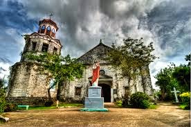
The hilltop Church of St. Michael the Archangel was said to have been built in the 17th century by Fr. Cristóbal Miralles.  It was burned and looted of its treasures on Corpus Christi Day during a slave raid in 1663. In 1845, it was repaired by Fr. Domingo de Madrid who also built a bell tower, a stone and coral convent, and a cemetery with a small chapel within.  It was damaged by a storm in 1880.  In 1894, Fr. Vicente Gutiérrez replaced the church roof with galvanized iron.

The convent, adjacent to the church, was the headquarters and hospital of the U.S. 9th Infantry around the time of the attack on Company “C” in Balangiga. A month later, the convent became the headquarters and hospital of a battalion of U.S. Marines under the command of Maj. Littleton W.T. Waller, which was attached to the Sixth Separate Brigade under Brig.-Gen. Jacob H. Smith. This Marine battalion was tasked with turning southern Samar into a “howling wilderness.”  During the Liberation, it was used as an evacuation center by Leyteños.

Sto. Nino Shrine and Heritage Museum

STO. NINO SHRINE AND HERITAGE MESEUM
At first this attraction doesn't seem like much more than a tiny shrine you can see from the entrance but once you go inside and begin your tour you will learn that it is much more than that. 

The heritage museum part of the old Marcos/Romuldez ancestral home is exquisite. Built by controversial former Philippine President Ferdinand Marcos and his wife Ismelda, this home is filled with treasures from all around the world. The tour takes you through the guest rooms surrounding the shrine downstairs as well as the family living quarters upstairs. Mementos/artifacts range from a chair the pope sat in when he visited Tacloban to a huge collection of Ming vases and ivory carvings from China. The museum is a testament to the lavish lifestyle of the Marcos' family before their exile to the United States. This hidden treasure in Tacloban is definitely worth visiting.

The Santo Niño Shrine, one of the 29 presidential rest houses that the late Pres. Ferdinand Marcos had built. There is an Olympic sized swimming pool the behind the building. 

The entrance to the Santo Niño Shrine. The Santo Niño is at the far end of the entrance. On both sides are a number of guest rooms with various themes. 

Santo Niño, a representation of the infant Jesus Christ, is the patron saint of Leyte.

It is located in Real Street, Tacloban City. Paintings of the 14 stations of the Cross done by Filipino artists, wooden bas-relief of the legend of the First Filipino man-woman (Si Malakas at si Maganda); tastefully decorated guestrooms of varied Filipino motifs; image of the Holy Child; a collection of original paintings by Fernando Amorsolo; spacious ballroom; priceless. collector's.

San Juanico Bridge

SAN JUANICO BRIDGE

This huge bridge is unique in the Philippines by its size, beauty and usefulness. It cannot be missed when you cross over from Samar island to Leyte island and avoids you the crossing of treacherous waters with high current. One sections rises very high so that large size ships can pass under and allows the large unsupported part its structural strength.

The San Juanico Bridge is the longest bridge in the Philippines, with a length of 2 km. It crosses the San Juanico Strait, bridging the islands of Samar and Leyte. It is also known as the Marcos Bridge, it is said to have been presented as a Gift and "Testimonial of Love" by the Philippine President Ferdinand Marcos to the first lady, Imelda, a native of Leyte.

It connects Tacloban City on the Leyte side and Santa Rita town on the Samar side. It offers many picturesque views, especially of the San Juanico Strait with its thousand whirlpools as well as the islets of the province. It is the narrowest strait in the Philippines & separates the islands of Samar and Leyte. At its narrowest point, the strait is only 2 km wide.  

It is approximately 10 minutes from downtown Tacloban City and is accessible by passenger jeepney, bus, motorcab or private vehicle. Construction on the $21.9 million Bridge was started in 1969 and completed four years later.

Tongonan Geothermal Power Plant

TONGONAN GEOTHERMAL POWER PLANT
For years, I’d only hear talks on how beautiful it is in Tongonan, Leyte – how cool the place is, elevated thousands of feet above sea level, with lots of virginal forests and wildlife – but never getting the chance to actually go and see the place. I’ve spotted that directional sign saying, “To Tongonan” hundreds of times when driving from Tacloban City to Ormoc City. Never been there… until last September. Some friends, Danny Fuentebella and Butch Celestial, asked me: would I be interested in joining their group and “camp out” in Tongonan? Gee, how could I resist such an opportunity?!

Nestled high up in the mountains in Tongonan between the municipality of Kananga and Ormoc City is the PNOC-Energy Development Corporation’s Leyte Geothermal Production Field (LGPF).

PNOC-EDC remains to be the country’s largest producer of geothermal energy. The 107,625-hectare Leyte Geothermal Production Field (LGPF) alone produces 708 MW. Here in this geothermal energy area, considered the largest wet steam producing field in the world, are the 112.5 MW Tongonan Production Field, the 132 MW Upper Mahiao Power Plant, the 232.5 MW Malitbog Power Plant, the 180 MW Mahanagdong A and B Plants, and the 51 MW Optimization Plants.

The Leyte geothermal plants currently supply power not only to the Eastern Visayas region, but also to Central and Western Visayas and on to Luzon via submarine cables. It is expected to serve as the linchpin of the national electric highway upon installation of another submarine cable from Leyte to Mindanao.

Due to bad weather, it was unfortunate that I couldn’t get closer photos of the plants (besides, in most areas near the power plants, taking photos is strictly prohibited for security reasons.) So what I have here are mostly panoramic shots, taken before a heavy downpour and thunderstorm suddenly set in.

WWII Veterans and Centennial Park

VETERANS CENTENNIAL PARK
The Veteran’s Park was constructed in early 1990s in honor of the Filipino soldiers who fought for the liberation of Leyte and the Philippines. The Centennial Marker was erected in 1998 to commemorate the 100th year of Philippine independence. One gets a good view of the bay, the port and the plaza from this point. It is a favorite rendezvous for the young and old alike for picnics and leisurely strolls on its verdant lawn. And from here, one can experience the refreshing breeze from the sea and witness the magnificent beauty of the sunset.

Lake Danao

LAKE DANAO
It was originally named "Lake Imelda" and was declared a national park on June 2, 1972 by virtue of presidential memorandum issued by then President Ferdinand Marcos. Later it was renamed and declared as Lake Danao National Park on February 3, 1998 through Proclamation No. 1155 and is now protected by Republic Act No. 7586 otherwise known as the National Integrated Protected Area System (NIPAS) Act of 1992. The lake supplies potable water to at least seven towns in Eastern Leyte including Tacloban City as well as the source of irrigation for ricelands in some municipalities like Dagami, Burauen, Pastrana and Tabon-tabon.

The trip up the mountain is interesting, special and very memorable. Different people in the mountains who really love nature, and flowers. Plantations of sugar cane, and pineapples along the way. Once the you have several options with wooden rafts to rent, and view up on the other side of the lake.

Scenic and serene. You can just stay here and watch the beauty of nature. You can also rent a boat or kayak to really enjoy its beauty. I would recommend anyone to visit the place when you're in Ormoc. To access Lake Danao via public Transport, there is a terminal near Ormoc Port (just beside it across the road). The fee is PHP30.

Very beautiful place. Even if when I was there it was jut after the typhoon and there where a lot of damage. I guess until now they are back to normal. They do have pick-nick places and even toilets ( but don't expect western standard high-tech toilets) Don't forget to have a pullover or vest with you. It's up in the mountains and like all mountains weather can change fast and it gets quite cold. BBQ places to rent, boats also, you can walk hours in a almost totally virgin nature. Have to visit there its a must. They ask a very little fee when entering.

Kalanggaman Island

KALANGGAMAN ISLAND
This is Palompon’s paradise.  Kalanggaman is considered the most beautiful beach  the province of Leyte has to offer.  The postcard-perfect virgin island with its powder white sand, clear waters, and cool breeze is certainly a virtual place very close to heaven.
What makes this island unique from others is its long sandbars that are stretching on both sides of the island.   The one hour bo

at ride to the island may be a bit challenging bur it is all worth it when you finally set foot on this paradise. If you want to forget your troubles for a  day or if   you want to have a quick getaway with your loved ones, Kalanggaman is definitely the place to go.

You can read a good book without many people kicking sand on your face, you can take amazing photographs all day long, or you can feast on fresh seafood until you tummy grumbles.
Flat limestone covered most of the shore on the other side. This goes all the way to the shorter and narrower second sandbar on the other tip of the islet. The other side is also less frequented by tourist. If you intend to be by yourself, this is probably where you would want to stay to swim or watch the sun make the sand shine like pearls when hit by its rays. Just make sure somebody knows you are there.

Spent another day in the island and savored its unspoiled and unique charm. It was an excellent and off-beat destination to clear my mind and recharge my soul. The island is also a haven for birds hence the name Kalanggaman Island.

HOW TO GET THERE:

Palompon, Leyte (see map) is the jump-off to Kalanggaman Island. Register and pay the fees at the tourism office. They will also assist you with your boat. Check rates here. It is a 1-hour boat ride from the mainland to the islet.

Monte Cueva

MONTE CUEVA

Up in the hills at Brgy Rizal, at an elevation of 172 meters above sea level overlooking Maasin City, the capital of Southern Leyte, is a small cave which was developed by its original owners into a shrine with a quaint chapel inside it.

Over the years, the Monte Cueva de la Virgen Shrine has become a site for pilgrims and devotees and has become one of Maasin’s popular tourist destinations.

It’s not for those afraid of heights nor for those with weak knees…

When I first got to the site together with a group of tourism officials about 2 years ago, I faced the prospect of a laborious climb up the hill via a zigzagging concrete stairway consisting of more than 400 steps! Having had no sleep the previous night after a long trip from Surigao, I politely declined the challenge and handed over the camera to my wife who was up to the dare to conquer the hill.

Later, upon seeing the pictures she took, I was regretful I didn’t join the climb. Next time, I told myself.

Last Friday, we were in Maasin and my mind was made up I had to make THE climb. Upon reaching the site, I saw some improvements, notably the construction of a new concrete stairway which local folks say is more difficult to climb due to the steep design. And more steps than the old stairway. So, we took to the old, but reliable stairway, zigzagging and snaking its way up beneath a cool canopy of trees.

City is the provincial capital and a 4th class city in the province of Southern Leyte, Philippines. It is the capital city of Southern Leyte.

One of the must see place in Maasin   is located  Up in the hills at Brgy Rizal ,2km from Maasin City,the Monte Cueva Shrine. The Conte Cueva is a small cave which was developed by its original owners into a shrine with a quaint chapel inside .

The shrine is located at an elevation of 172 meters above sea level overlooking Maasin City. A donation by the philanthropists Odong and Loring Chung to the Diocese of Maasin .

The shrine is  not for those who are afraid of heights nor for those with weak knees because before you reached the Monte Cueva you must conquer first the laborious climb up the hill via a zigzagging concrete stairway consisting of more than 550 concrete stairways. I took a couple of rest on my way up. The climb was even more difficult and steeper  as I approached the last 20 steps.

But I was awed upon seeing the entrance of the shrine. I couldn’t  believe seeing a church inside the cave. The natural characteristics of the cave was maintained, in fact in some parts of the chapel were some waters dripping from the ceiling and is being collected in several vessels. Its walls are made of limestones and the floorings are tiled. Right on top of the altar is an opening of the cave creating  an amazing  effect  to the chapel.

Over the years, the Monte Cueva   has become a site for Catholic  pilgrims and devotees and has become one of Maasin’s popular tourist destinations.

How to get there:

From city proper of Maasin, just take a ride of trike and told to the driver that you’ll going to Monte Cueva. and that’s it. laborious climb up the hill via a zigzagging concrete stairway consisting of more than 400 steps (172 meters above sea level)

MacArthur National Park

MACARTHUR NATIONAL PARK
The McArthur Landing Site in Palo, Leyte was created to commemorate Gen. Douglas MacArthur famous parting words “I Shall Return” that he made good of his promise before he left the country after its downfall to the Japanese Imperial Army during World War II. This famous event took place on October 20, 1944. The Allied landing on Leyte Island’sea shores was a pivotal moment in the history of the War in the Pacific and in the human struggle for liberty. Worth a visit.

This most important historical memorial makes for great pictures. The statues are very lifelike.

Thank God for America!

There is an icecream seller at the road and other small shops nearby.

The Memorial is just down the road from the 10 month old Oriental Hotel in Palo, three or fouir kilkometres from Robinson's Tacloban mall.

Even as a tourist spot, it's quite peaceful. There are not much stalls selling stuff, which is good. The place is right next to the sea, and it's very relaxing. You can bring along stuff for a picnic if you want. I just hope the local government could fix up the area with friendship plaques from all over the world, because it's really educational.

Agutay Island

AGUTAY ISLAND
Agutay is a barangay of the philippine municipality Maripipi in the province Biliran in Eastern Visayas which is part of the Visayas group of islands.

Agutay belongs to the barangays of Municipality Maripipi which are in the outlying area.

The municipality Maripipi with a population of about 6,946 and its 15 barangays belong to the partly urban areas in the Philippines. While some of the barangays developed modern urban structures, some others, especially those which are seated in the outlying areas, remained rural. By the end of 2007 Agutay had 525 residents.

Ulot Watershed Ecotourism

ULOT WATERSHED ECOTOURISM
The 455,700 hectare SINP, the biggest natural park in the country, was declared a protected area on April 13, 2003 by virtue of Presidential Proclamation No. 442.  It covers 333,330 hectares of land and a buffer zone of 125,400 hectares of primary forest and a large, contiguous tract of secondary forest in good ecological condition.  It boasts of many caves, various wildlife species and river systems such as the navigable, 9-km. long Ulot (a Waray term meaning “monkey”) River, which is within the Ulot Watershed Area, one of Samar’s 8 watershed areas.

Ulot River is Samar’s longest river with a total length of 90 kilometers. Counting its numerous tributaries, it’s total length has been estimated to reach over 500 kilometers.

The river is located inside the protected area covered by the Samar Island Natural Park (SINP), created by PD No. 442 (August 13, 2003) – an area considered one of the country’s top botanical diversity centers.

SINP’s total land area is 330,300 hectares with a buffer zone of 125,400 hectares for a total of 455,700 hectares encompassing 36 municipalities in the 3 Samar provinces – Samar, Northern Samar and Eastern Samar.

The natural park boasts of some 38 species of mammals (50% endemic), 215 species of birds (55% endemic), 51 species of reptiles (69% endemic), 26 species of amphibians (52% endemic) and over 1,000 species of plants (53% endemic).

To those not yet familiar, Samar island is the 3rd biggest island of the Philippines, after Luzon and Mindanao.

The Ulot Watershed Ecotourism Loop is the latest offering of SINP.

Aside from torpedo boat adventure ride, the Ulot Watershed Ecotourism Loop also includes such activities as kayaking, tubing, swimming and inland game fishing along the rugged and unspoiled waters of Ulot River.

They offer packages which include the entrance and community development fees, rental of the boats, kayaks and tubes, life vests, protective helmets and other equipment, and the services of tour guides and boat men.

There are rooms available for rent at the SINP Headquarters.

The ecotourism loop is set to be formally inaugurated and opened to the public on November 30.

HOW TO GET THERE:

The Ulot Watershed Ecotourism Loop is located at Campo Uno, Brgy. Tenani, Paranas, Samar. Driving along the Maharlika Highway between Tacloban City, Leyte and Catbalogan, Samar, one takes the road headed towards Borongan, Eastern Samar at the road junction at Buray. The SINP is some 16 kms from the Buray Junction. Travel time by car from Tacloban City, Leyte is about 1.5 hours.

Sohoton Cave

SOHOTON CAVE
The park is situated at Rawis, Brgy. Guirang, Basey, Samar covering an approximate area of 840 hectares.  Fascinating geological features abound in the area of the national park such as caves, hugs, limestone boulders, rockholes, weathered formation rocks and underground rivers.

The most prominent assemblage in the park is the cathedral-like caves, which are the Panhulugan I, and II, Sohoton and Bugosan.  All the caves in the park are endogen caves in angular limestone cliff, which support the base of other crack system.  It abounds with flowstones and dripstones.  Two and a half (2½) hours motorboat ride from Tacloban City and two (2) hours ride from Basey proper can reach these tourist spots in Basey.

A fantastic huge arch-shaped rock that connects two mountains ridges spanning the Sohoton River.  It has a vertical clearance of 23 feet, about 8 meters in width and 40 meters in length.  The Stone Bridge is forested at its upper portion while on its underside hang heavy karst formations of giant stalactites forming like swords and rockets.  This is located within the Sohoton National Park in Basey.

Nasunugan Watchtower

NASUNUGAN TOWER
The Biliran Watchtower at San Roque, also known as the Nasunugan Watchtower is thought to date back to when the Spanish ruled the Philippines and are possibly connected to the nearby San Roque Chapel ruins. From the hill you can see views across to Leyte Province and you understand how this watchtower was a very important defensive position for Biliran Island. 

How do I get there?
As you come across the Biliran Bridge and enter Biliran Island the old Nasunugan Watchtower is on the small hill to the left. As you enter the Island look for a set of steps on the left hand side of the road going up the hill that take you straight up to the Biliran Watchtower.

Below the quadrangle is a triangular terrace surrounded by crumbling walls of coral stone blocks. The terrace ground is overgrown with banana clumps.

The original structures here were probably built around the time of the Biliran Religious Revolt from 1765 to 1774. Their architecture is original; they have not been patterned after other Spanish churches and watch towers found all over Leyte and Samar.

The Biliran revolt was led by Padre Gaspar Ignacio de Guevara, a native priest from Samar who was the first parish priest of the Biliran pueblo. He broke away from the Catholic Church, formed his own sect, and experimented with a commune society for the natives in the forest of Biliran, some eight kilometers from its protective fortress.

Padre Gaspar was captured by Moro pirates and drowned around 1774. The pirates or his followers later burned his forest commune and the structures in the existing ruins.

Agta Beach Scuba Resort

AGTO BEACH SCUBA RESORT
Agta is the most probably the most popular Beach in the whole of Biliran Province, with its beautiful sand set in a sweeping enclosed bay its a perfect setting. Agta Beach Resort has a selection of seating areas beside the beach with amazing views across the water to Capinahan and Dalutan Island's. 

How do I get there?
The Agta Beach Resort is Easy to find along the Biliran Circumfernetial Road going north from Naval, and it just past the town of Almeria. Keep a look out for the carved wooden sign at the entrance and follow the drive down the hill to the Resort and Beach.

Agta Beach Resort is located at Almeria, Biliran, Philippines. It is approximately a 2-hour drive from Tacloban, which in turn is a one-hour flight from Manila, the country’s capital.

This is the first scuba resort in the province hence it being a haven for scuba divers, featuring easy access to interesting diving spots and tranquil waters.

Tinago Waterfalls

TINAGO FALLS

There really is something about waterfalls that I am consistently drawn to them. My must-sees on every destination are churches, waterfalls, and beaches. And so when I went to Biliran, a small province in the northern part of Leyte, on October 2013, I sought my must-sees. But for now, allow me to share with you my visit to Tinago Falls of Biliran.

We were only able to explore three waterfalls due to time constraints. I took this as a reason for me to come back. Tinago Falls is the most popular waterfall among the more than 2 dozens of waterfalls in the province. It sits on Cabibihan Village, approximately 4 kilimoters before the town proper of Caibiran, Biliran.

The word "tinago" actually means hidden in English. The name became ironic when the waterfall became more accessible to people when the Naval-Caibiran Cross Country Road was constructed. An off-road vehicle is a better choice of transportation to reach Tinago Falls. An alternative is to ride a motorcycle that takes about 40 minutes from Naval (the capital of the province). A vast rice field is the view approaching the entrance to the falls and there is a concrete stairway leading to the view deck that provides the best view of the 80 foot high waterfalls.

I watched in awe as the raging water dropped from the limestones surrounding the natural pool. I could spend a whole day here just listening to the sound of the water splashing and enjoying the refreshing water.

The most hypnotic waterfalls magnificently lay its beauty in the heart of Caibiran rainforest, a loop trail taking 10 minutes from the highway. A hideaway that blends perfectly for nature lovers; rich blend of trees, vines, & other exotic plants accompanied by the cooling & enchanting sounds of rushing streams.

Tinago Falls can be reached via Tacloban City with domestic flights from Manila and Cebu. From the airport, take a cab and alight at the van terminal bound for Naval, located in the corner of P Burgos and Salazar Streets (van fare is around P150). Travel time is about 2 to 2.5 hours. 

There are also ferries from Cebu City traveling directly to Ormoc. From Ormoc, there are vans bound for Naval. Roro boats are also traveling from Cebu to Naval and vice versa, check the schedule here.

From Naval, inquire for habal-habal (motorcycles for hire) going to Tinago Falls. Reasonable rate is P500 round trip. Hopefully the local government can do something about the transportation to Tinago in the immediate future. Entrance fee is P10 for adults and P5 for children.